

Mayor Bailey proclaimed September 4, 2018, as Julie (Braden) Main Day and thanked her for 33 years of service to the City of Coronado.
The Active Transportation Plan (ATP) discussion was continued from the July 17 meeting. “This revised plan is a middle of the road guide for both pedestrians and bicycles,” said City Manager Blair King. The State mandates that the city have an ATP in place. During Oral Communication, several residents spoke in favor and against the ATP and offered suggestions.
Allie Scrivener, Associate Active Transportation Planner, answered Councilmembers’ questions that were raised at the last meeting. She shared that the refined costs for bike lanes are now projected at $28,000 per mile, down from the original $70,000 per mile cost for a Class II facility. The original estimate was based on regional construction costs with a traditional bid approach, while revised costs are based on an in-house design with local construction. The estimated cost for bike routes is $7580 per mile. The original proposal for the Alameda bike lane was from 1st to 10th Streets, and the new proposal is from 1st St. to Ocean Blvd. Staff looked at the Ticket Diversion Program, which was conducted by the Police Department, but was discontinued due to lack of use. Bicycle ticket fines were reduced in 2017 and staff thinks this potentially reduced incentives for participation. During the months of May, June and July 2018, two citations were given to bicyclists, along with 46 stops and 36 verbal warnings.

In response to additional questions, Scrivener pointed out that Class III bike routes may have either signage, pavement markings, or both. Class II requires signage at the beginning and end of the routes and at changes in direction. Bike Lanes were proposed on Alameda and Pomona Avenues to facilitate safer travel on streets where bicyclists are already using them as a direct route across the city with fewer signals.
The Mayor suggested going through the nine priority projects out of the 21 total projects to see if there was a consensus around each of those items, or if there are modifications or oppositions and then vote on the entire plan.
- D Ave. ~ Safe Routes to School Connection, Class III signage and striping proposed. Councilmember Downey pointed out that D and H Avenues are unique in our community allowing students to go all the way through to school. She also noted that bike lanes help teach young riders where to ride on the road. Everyone agreed that sharrows would be helpful for the diagonal parking areas.
- 10th Ave. ~ Class II Bike Lane proposed with striped lane and signage.
- Alameda Blvd. ~ Class II Bike Lane proposed with striped lane and signage.
- C Ave. Safe Routes to School Connection ~ Class III Bike Lane with truncated domes and repainting of high visibility crosswalks proposed.
- Ocean Blvd. ~ Residents have voiced concerns on the extended median and rapid flashing beacons, so those were deleted from this proposal, but includes signage, painting and repainting of sidewalks, and small “comma-shaped” turning delineators proposed.
- Palm Ave. ~ Installation of high visibility crossings at the 10th Street intersections and truncated domes proposed.
- Olive Ave. ~ Installation of new crosswalks and painted curb extensions with truncated domes.
- A Ave. ~ High visibility crosswalks proposed at 1st and 2nd Streets.
- Priority Non-infrastructure Plans, which includes a Safe Routes to School Program with multi-pronged Bicycle Safety Education Programs, and other city-wide plans with a budget of $20,000 – $50,000. The remaining items are minor improvements for pedestrians and other bicycle routes.
» Details of the nine priority projects «
The Mayor asked to move forward with this plan as is with the changes of updating costs, installing as few signs as is legally required for the bicycle markings on designated streets, deleting the rapid flashing beacons at the crosswalks and using “comma-shaped” turning delineators for the Ocean Blvd and Isabella Ave project. After much deliberation on this issue, the Council ultimately unanimously approved this conceptual plan. Specific projects will come back for final approval.
Councilmembers Donovan had additional ideas and he and Councilmember Sandke will work to provide a list to help reclaim the roads for our citizens, including looking at 20 mph speed limit, bike diversion program, no smart phones while crossing streets, landscaping opportunities, etc.
Harris & Associates, hired by the city to create a Utility Undergrounding Master Plan, made a presentation on their findings. They have extensive experience doing this in other cities like Laguna Beach and Berkeley. City Manager pointed out that they looked at cost assessment, identified utilities locations, funding alternatives, and developed an internal ranking criteria for prioritizing areas. The next step is holding community meetings, looking at funding strategies and returning to the Council with finalized information.
They highlighted the reasons to underground utilities which include: Increased public safety, reduced fiscal risk and liability, strengthen service reliability, minimize clutter and enhance aesthetics, increase property values and tax base, and promoting accessibility and walkability. With 28.1 miles of 1521 utility poles in Coronado, it would cost a total of $175.5 million to underground all the utilities in town. Since this is cost prohibitive, they created a methodology, using 13 criteria, to prioritize the city into 12 areas, and they recommend focusing on the public right of ways to achieve the greatest community benefit. The top three areas were:
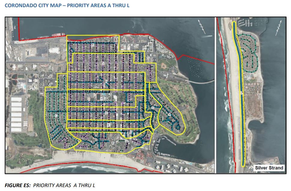
- 1st and 2nd Street Corridors (Area K)
- Margarita Ave./Bay Circle (Area A)
- Pomona Ave (Area G)
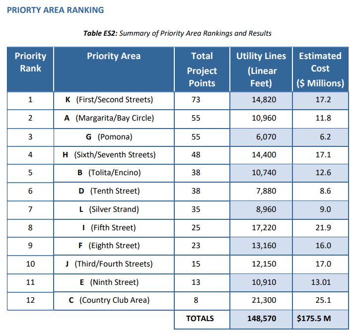
 Projected costs include: $1000 per linear foot for roadways with public right of ways, $1200 per linear foot for alleys, and $1400 per linear foot for rear yard easements. Costs can vary per project. The estimated cost to do these first three projects is $70.9 million, which would remove almost 700 poles, or about 40 percent of the city’s total utility poles.
Some funding options include: CPUC Rule 20 funds, CDA loan repayment funds, assessment or special taxes, Inter-agency trading of Rule 20(a) credits with other jurisdictions, pay as you go, local surcharge, increase in sales tax, utility tax and/or transient occupancy tax, or city general obligation bond or general fund contribution.
The next steps would be community outreach and input, policy decisions, prioritize areas, conduct detailed cost analysis and engineering, and finalize the funding strategies and schedules. Councilmember Downey had concerns about the criteria the study used and wanted to re-evaluate the proposed areas. She also was a proponent for finishing the Strand project.
During public comment, Liza Butler and Marvin Heinze, both Cays residents, expressed that they would also like to see the Strand State Scenic Highway utilities project completed. It has different factors than the Village, which includes other federal grants and local funding and labor from the military. The Strand project cost $1 million for twice the proposed area of the current projection in the Harris study of $9 million.
The motion volleyed back and forth before the Council voted 4-1 with Councilmember Downey opposed, to accept the independent, third-party analysis and program prioritization developed by Harris & Associates for the Coronado Utility Undergrounding Master Plan. They directed staff to re-evaluate the Silver Strand area using the criteria the Harris analysis lays out; hold public workshops to address concerns from the community; and prepare and return to the City Council an implementation plan focused on undergrounding the highest ranked areas based on the Harris Plan and community feedback.
Other agenda items ~
The Council unanimously adopted an ordinance requiring Wireless Communication Facilities to comply with the new proposed placement and design guidelines.
Tricia Olsen, Associate Planner presented two approvals for Historic Alternation Permits from The Historic Resource Commission (HRC) for 855 Alameda Blvd and 535 Ocean Blvd. Both permits were unanimously approved.
Three applicants, Wanda Brothers, Karen Strouse and Frederick Zarndt applied to be on the Library Board of Trustees. Wanda and Frederick were not in attendance, and Karen spoke on her own behalf. The Council voted to appoint Karen Strouse and Frederick Zarndt to the two Library Board of Trustees positions. They will each serve a three-year term.

